Levi Leipheimer is a diviner of pain and suffering par excellence — a bike race organizer. We asked him to cull his dark arts and assemble 10 rides in the scenic, relaxing and overall pleasant area that is Northern California’s wine country.
Levi Leipheimer’s a diviner of pain and suffering par excellence. He whips up velo torture for himself and organizes it for races. We asked him to cull his dark arts and assemble ten rides in the scenic, relaxing and overall pleasant region of Northern California’s wine country. In Napa and Sonoma counties, there’s a spot for a 90-point Napa Cab and tasty crostinis on every corner; but if you want to feel a lactic burn that ignites like lighter fluid in your veins, that’s not so obvious. Thankfully, Levi knows the spots, and he brought together the 10 best. We’ve assembled in graduating length and difficulty. Enjoy them responsibly.
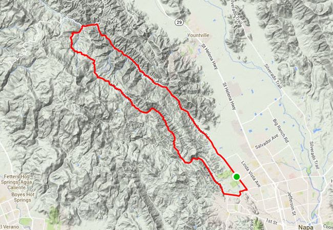
Distance: 21.1 miles Elevation Gain: 1,715 feet Starts From: Napa Levi’s Take: This short-but-sweet loop out of Napa City could make for a recovery spin, except for the medium length climb up Mt. Veeder Road. You will be rewarded with a fast and fun descent back to town, though. Road Notes: It’s up and down, folks. Spin it out for the first quarter, climb through the middle, then descend back to town. Oh, and wide views of wineries draped along the ridge should inspire a few more pedal strokes.
Distance: 43.1 miles Elevation Gain: 2,533 feet Starts From: Santa Rosa Levi’s Take: Starting at NorCal Bike Sport, head north out of town via Mendocino Ave to Old Redwood Highway. Soon you’ll be on one of the most ridden roads in the county, Chalk Hill Road. Then Highway 128 takes you south to Franz Valley, a quiet road in Knights Valley. Road Notes: If you need a quick tuneup before heading out (or a quick bottle fill), the guys at Norcal are here to help. Then do as the locals do, and ride past the wineries and vineyards on Chalk Hill. It’s not a bad life.
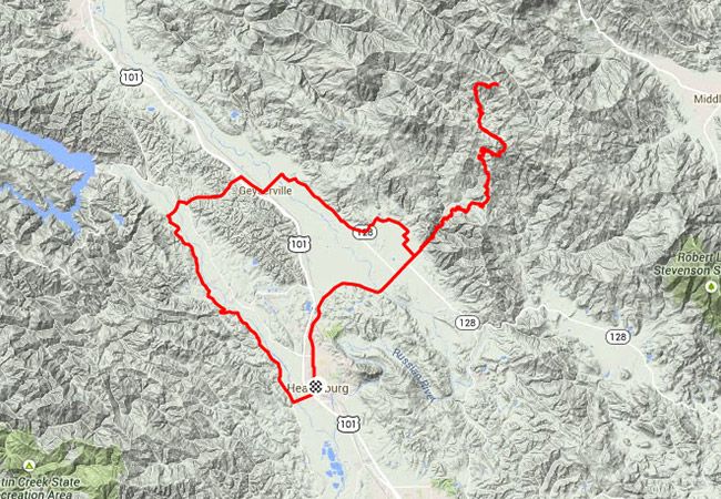
Distance: 51.1 miles Elevation Gain: 4,286 feet Starts From: Healdsburg Levi’s Take: No trip to Sonoma County would be complete without standing atop the famous Pine Flat Road. Start in Healdsburg and head straight for the Alexander Valley. Stop at Jimtown (for provisions), and then get climbing. This climb is roughly 11 miles and, just before the summit, features some of the steepest pavement in the county. After descending (watch for oncoming traffic), loop north through Geyserville and stop for some Diavloa Pizza. Then head south on West Dry Creek back home. Road Notes: There are men and there are boys. Men climb Pine Flat. Boys quiver in its shadow. If you’re feeling cocky, try taking on Levi’s KOM time for the trip up: 45:02.
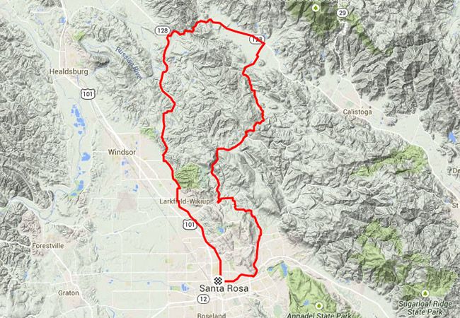
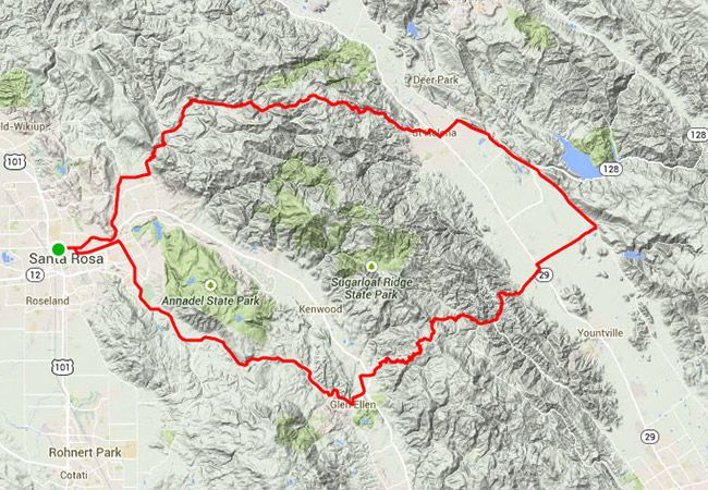
Distance: 51.8 miles Elevation Gain: 4,505 feet Starts From: Santa Rosa Levi’s Take: Start at NorCal Bike Sport and ride out of Santa Rosa past the Riviera Ristorante on Montgomery Ave. After a few miles you take a right on Sonoma Mountain Road, and you’ll see why our roads are known for their “character” (make sure you have at least 25-centimeter tires with around 100 psi). Sonoma Mountain is a short, steep and rough climb towards the town of Glen Ellen, and you should take the descent with extreme caution.
After you pass through Glen Ellen the next climb awaits: Cavedale Road. Cavedale is frequented by many cyclists and is one of the roads the GranFondo committee helped to repair over the last couple of years — it also has a lot of “character.” On a clear day, you can see the city of San Francisco near the top of the climb. The descents down Cavedale and Trinity Road also require extreme caution. The roads that take you back to Santa Rosa are small, twisty and hilly little pieces of a puzzle that only the locals know. There’s a little bike/pedestrian bridge that connects the Oakmont Retirement Community to Channel Drive next to Annadel State Park, but the Route Builder wouldn’t accept it; I guess that little connector will stay in the local’s secret stash. Road Notes: When a climber calls a climb “steep and rough,” you should be halfway to granny gear and settling in for an uphill battle. When a climber throws not one, but two “steep and rough” hills your way, you’re going to be wishing you had a triple. This ride is not short, not sweet, and not easy. Have fun.
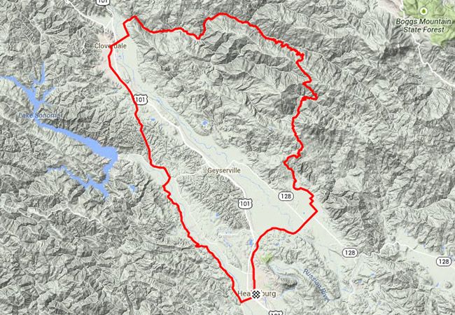
Distance: 55.9 miles Elevation Gain: 4,686 feet Starts From: Healdsburg Levi’s Take: Starting on the square in Healdsburg, you head north on West Dry Creek Road past the wineries in the Dry Creek Valley. Dutcher Creek takes you to the town of Cloverdale, and it’s a good idea to stop for water before tackling the remote loop over Geysers Road. The next stop is down in Alexander Valley at Jimtown, which is only a few easy miles from where you started in Healdsburg. Road Notes: The natural phenomenon from which this road takes its name shoots water straight up in the air, so, naturally, the road shoots (you guessed it!) straight up. Peaking out at about 13.5 percent, it’s enough for you to pop a few wheelies while pumping the pavement. Enjoy the burn. Love the hill. Sweat like a geyser.
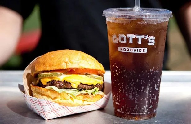
Riding bikes burns calories. Eating adds them. Balance the two properly, and you find a nice little harmony. Here are spots to stop while out on your pedal frenzy. Riviera Ristorante: “It’s kind of the clubhouse for the Sonoma County cycling community”, Levi says. There’s jerseys on the walls, everyone knows everyone, and it’s velo mecca for a carboload. The local’s choice? The spaghetti and prawns, aka “The Levi Leipheimer”. Santa Rosa. Jimtown Store: Every cyclist in the area knows Jimtown; it’s a must-stop on any ride. Levi says, “I’m always there on my bike, so I don’t get a lot of food. I always get their homemade cookies, or in the winter their Mexican hot chocolate. Or, you can just stop and fill up your bottles on the side of the building.” Healdsburg. Diavola Pizzeria & Salumeria: If you want Levi calls “really, really good pizza”, this is your spot. Levi goes with the namesake, the Diavola, but you can’t go wrong here. Geyserville. Gott’s Roadside: “There’s a huge line there every time I go. It’s pretty awesome.” The stand serves elevated burger stand fare — organic shakes and angus beef patties. They also have a huge lawn to stretch the hammies. St Helena. Velo Vino According to Levi said, “They have this Bruschetteria Food Truck there now, and it’s awesome.” Wine. Bikes. Bruschetteria. Sounds just right. St. Helena. Bergamot Alley: The bar rests next to Campo Fina, and so the thing to do, as Levi says, is to “order food in Campo Fina and bring it over to the Bergamot. It’s a thing we always do.” Healdsburg. Bottega: It’s Chef Michael Chiarello’s place. Levi says he “had a ride this spring and the rest stop food and the food afterwards were [both] incredible.” Rest stop food or restaurant food, this is the reward for your hard work. Stop here last, fuel up with deliciousness, and start plotting your next trip to wine country. Yountville.
Napa Nosedive
Distance: 57.2 miles Elevation Gain: 5,303 feet Starts From: Santa Rosa Levi’s Take: Starting from NorCal Bike Sport, head past the Riviera down Montgomery Road; make a right on Yulupa, which eventually joins with Bennet Valley Road. You’re spared from the steep pitches of Sonoma Mountain by staying on Bennet Valley all the way to Glen Ellen, but you don’t get out of the pitches of Trinity Grade, climbed in the Coors Classic as well as the Amgen Tour of California. The backside is a descent to take with extreme caution, especially the very fast Oakville Grade that literally drops you into the Napa Valley. Head North on Silverado to pass by Velo Vino in St Helena before tackling the brutal climb up Spring Mt. Road, then you can coast back into Santa Rosa. Road Notes: The inclines clench the quads, but the downhills are the real sphincter-tighteners. Check the brakes at the top — we don’t want any Sonny Bono’s on the descents.
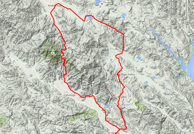
Distance: 58 miles Elevation Gain: 4,634 feet Starts From: St. Helena Levi’s Take: Start at the Clif Family Velo Vino Tasting Room in St. Helena, then head north on Silverado Trail until the first big climb up Old Toll and Highway 29. Once up and over, you get to Middletown, where you’ll want to stop for water. Then it’s south on the desolate Butts Canyon Road to the next climb up Ink Grade. Ink is one of the more gentle climbs in the county and goes in and out of the Redwoods; then it’s one last descent down Old Howell Mount right back to Velo Vino. Road Notes: Big trees on a winding, casual incline — now that sounds nice, doesn’t it? You do your hard work early on in this route (miles 12 through 18 kind of suck), and then reward yourself the rest of the way. Because you deserve it. You really do.
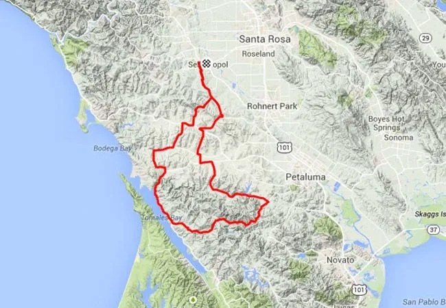
Distance: 64.3 miles Elevation Gain: 4,646 feet Starts From: Sebastopol Levi’s Take: Starting in Sebastopol at Fork Cafe, head south towards Bloomfield Road and the grassy green hills of Southern Sonoma County and Northern Marin County. There are plenty of groves of eucalyptus trees to help you breathe on this ride. There aren’t any long climbs, but the loop, with lots of short steep punchy climbs, is deceivingly difficult. Road Notes: There’s nothing wrong with hitting granny gear on a climb. Nothing at all. It’s normal. And, if you find yourself landing there every quarter mile on this route, that’s fine. It’s normal. Nothing wrong. We did it, too.
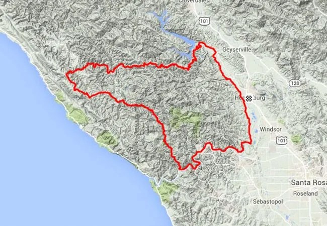
Distance: 98.9 miles Elevation Gain: 9,101 feet Starts From: Healdsburg Levi’s Take: Start from Healdsburg and head north on West Dry Creek. Keep going to Lake Sonoma and you’ll reach one of the most epic roads in the county, Skaggs Springs Road. This loop, which heads the opposite way on the infamous King Ridge, is on par with the GranFondo. It’s hard, and only for experienced, fit riders. A key water stop is at the Boy Scout Camp on the South side of the road on Skaggs; they installed a spigot just for cyclists! Road Notes: Okay big boy. You wanted the major leagues, we got it: welcome to the Cal Ripken Jr. longevity express. This route is not for the faint o’ leg, and if you take a few recovery laps around the city square back in Healdsburg, you can tell all the buddies you did a century that morning. Not that you’d brag. But we might.
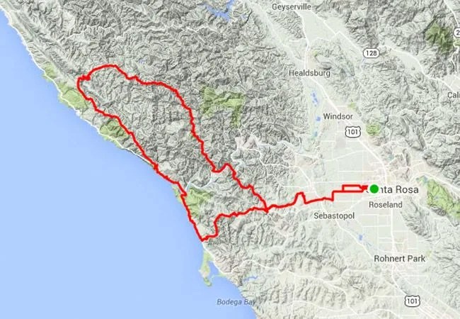
Distance: 100.8 miles Elevation Gain: 8,917 feet Starts From: Santa Rosa Levi’s Take: The King Ridge GranFondo. This is what you came to do. Road Notes: This is the carrot to hang: the GranFondo route, a fabled feat of endurance divined by Mr. Leipheimer himself. Love it, hate it, suffer for it, and crush it. Grab that carrot and gobble it whole, you animal.